Welcome to NEFF

Sign up for a new account today, or log on with your old account!

Give us a try!

Welcome back to the new NEFF. Take a break from Twitter and Facebook. You don't go to Dicks for your fly fishing gear, you go to your local fly fishing store. Enjoy!

Watch the Walton Guage

JOE.T

Dry Flies Only
If you have plans to fish the WB or Main ,Wade or float this weekend watch the Walton gauge..No room in the Cannonsville.

Even if Stilesville shows 1000- 2000 in the morning,it can blow out quickly from a big time spill !

If you see that the Walton gauge goes straight up don't even attempt to float,you could be out there and 5,000 plus wall of water catches up quick..There will be a delay from Walton cresting and stilesville going straight up..

Don't be fooled.

I bring it up because last year I helped a guy at the WB Angler Resort who had no idea what was coming..He was desperately trying to take out there ,I just happen to be there teaching my kids to throw streamers in the back channel from the ramp.That got real hairy.

Obviously watch Pepacton, and of course the Beaverkill for the East B.

I know most of you know this, but there are some who don't.

Be safe.


USGS Current Conditions for USGS 01423000 WEST BRANCH DELAWARE RIVER AT WALTON NY

Warnings for Delaware, New York | Weather Underground

Wise advice. We once put in at Stilesville at maybe 1500-1800 and it rained all day very hard, way more than the forecast and when we took out at Hale Eddy it flowing at at least 6000 and rising. Not a wall from a reservoir spill but sketchy nonetheless.
 
If you have plans to fish the WB or Main ,Wade or float this weekend watch the Walton gauge..No room in the Cannonsville.

Even if Stilesville shows 1000- 2000 in the morning,it can blow out quickly from a big time spill !

If you see that the Walton gauge goes straight up don't even attempt to float,you could be out there and 5,000 plus wall of water catches up quick..There will be a delay from Walton cresting and stilesville going straight up..


Don't be fooled.

I bring it up because last year I helped a guy at the WB Angler Resort who had no idea what was coming..He was desperately trying to take out there ,I just happen to be there teaching my kids to throw streamers in the back channel from the ramp.That got real hairy.

Obviously watch Pepacton, and of course the Beaverkill for the East B.

I know most of you know this, but there are some who don't.

Be safe.


USGS Current Conditions for USGS 01423000 WEST BRANCH DELAWARE RIVER AT WALTON NY

Warnings for Delaware, New York | Weather Underground


Lots of water here along the Susquehanna. Sheet flow down the hillsides. Ditches full and overflowing the roadways. I can only imagine it's the same up and over the hill in the D's watershed. Joe is more than right to say to watch the gauges.

At least there is will be enough water in the rivers to spread the boats and waders around the system... ;)

My generator just kicked on. I know we don't have any lightning around so I hate to think about why the power is out.
 
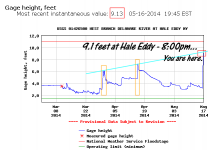
Wow Hale eddy is at 4,000 and going vertical, which is all from Oquaga creek not much from spilling yet.Walton has doubled ,I'm surprised it's not much higher with all the rain Walton has gotten already.

Was suppose to fish with NJ Fred tomorrow..Ain't happening...He shot me a text and said he was doing a float on WB and it went from about 800 to 3000 ish real fast..He said he was riding a big wave to get off the river quickly !

Plenty of free Yohoo though.
 
Hi Joe,

It is my experience that the spill is usually delayed long enough to not effect the maximum height very much if at all.

In a single day rainstorm the creeks below the dam start dropping almost as soon as it stops raining and this usually offsets the increase in spill from the reservoir.

What really gets us in trouble is a couple of stacked storms.

For the record we received 2.5 inches of rain so far here at the house. IT looks like there is still a bit of rain, but not very significant.

I was supposed to float today, it has been planned for months. Oops!!

Jim
 
For the record we received 2.5 inches of rain so far here at the house. IT looks like there is still a bit of rain, but not very significant.


Jim

--------

Jim Serio-

Why keep Cannonsville at close to or over 100% knowing that there is a significant rain event coming?

Radar and NOAA modeling showed this system at least 72 to 96 hours in advance of impact.

CHART:

051614_2.png
 
--------

Jim Serio-

Why keep Cannonsville at close to or over 100% knowing that there is a significant rain event coming?

Radar and NOAA modeling showed this system at least 72 to 96 hours in advance of impact.

CHART:

View attachment 10669


Because today just might be day one of the drought of record:crap: Unfortunately, that is how NY City has always managed (or mismanaged) their entire reservoir system and we all know it.

WB at Hale Eddy looks to be cresting out at about 8,100 cfs. Lots of water everywhere in the tri-state area this spring.
 
Because today just might be day one of the drought of record:crap: Unfortunately, that is how NY City has always managed (or mismanaged) their entire reservoir system and we all know it.

-----

Thank you for that observation.

Paging Jim Serio - is that the correct answer?

Please advise. Thank you.
 
Hi Tony,

1: Although storm looked like a near certainty, there is always some doubt as to if it will in fact hit and how much we will get. Look back at a couple of other predicted storms that did not materialize in our area this year.

2: If the storm hits, having released water just before the storm make actually make things worse for downriver areas.

3: Potential benefit of reducing crest is very low and may actually increase crest in certain areas downstream. See 2 above.

This storm is a very nice example. If NYC had increased release to 1500 about 48 hours before arrival of storm;

Reservoir spill would be delayed by perhaps 24 hours.

This would have reduced peak flow at Hale Eddy by about 400 cfs, or 7700 instead of 8100.

Peak flows further downriver may have actually increased because of the 1000 cfs already in the river.

FFMP has a mechanism in place to prevent this risk of making things worse. If the river levels are predicted to rise above a certain quantity, the releases are actually reduced before a storm to reduce downriver crests.

Taken from the FFMP:

iv. The current National Weather Service (NWS) flood stage for the West Branch Delaware River at Hale Eddy is 11.0 feet. Accordingly, Zone L1discharge mitigation releases will not be made from Cannonsville Reservoir when the river stage for the West Branch Delaware River at Hale Eddy is above 9.0 feet, or is forecasted to be above 9.0 feet within 48 hours of planned discharge mitigation releases, and releases shall be made in accordance with Zone L2 through L5 as provided in Tables 4a through 4g. This guidance may be modified at any time upon unanimous consent by the Decree Parties, if additional information demonstrates that a different cautionary stage should be used to limit the discharge mitigation releases.

Hope this helps,

Jim
 
Hi,

As expected, the river levels are dropping. The spill is inceasing. So far, the rate of the small feeders streams dropping is more than compensating the for the increase in spill from the reservoir.

Sometime later today or tomorrow the spill rate and stream drop will be the same and the flow at Hale Eddy will stabilize for some time.

I have seen a slight increase in the flow as the reservoir spill actually is greater than the drop from the tribs, but this is rare.

Cannonsville is predicted to max out spill at about 4000 cfs sometime Sunday morning.

Jim
 
Does the spill water have decent visibility? As the feeder streams drop and the spill increases the flow may remain about the same, but my question is if the water will become clearer? I've had a business trip planned for months that has me driving through there on Sunday. I was planning on floating Sunday night and Monday morning. Is there any chance I'll have enough visibility to chuck streamers from the boat.
 
Hi Tony,

1: Although storm looked like a near certainty, there is always some doubt as to if it will in fact hit and how much we will get. Look back at a couple of other predicted storms that did not materialize in our area this year.

2: If the storm hits, having released water just before the storm make actually make things worse for downriver areas.

3: Potential benefit of reducing crest is very low and may actually increase crest in certain areas downstream. See 2 above.

This storm is a very nice example. If NYC had increased release to 1500 about 48 hours before arrival of storm;

Reservoir spill would be delayed by perhaps 24 hours.

This would have reduced peak flow at Hale Eddy by about 400 cfs, or 7700 instead of 8100.

Peak flows further downriver may have actually increased because of the 1000 cfs already in the river.

FFMP has a mechanism in place to prevent this risk of making things worse. If the river levels are predicted to rise above a certain quantity, the releases are actually reduced before a storm to reduce downriver crests.

Taken from the FFMP:

iv. The current National Weather Service (NWS) flood stage for the West Branch Delaware River at Hale Eddy is 11.0 feet. Accordingly, Zone L1discharge mitigation releases will not be made from Cannonsville Reservoir when the river stage for the West Branch Delaware River at Hale Eddy is above 9.0 feet, or is forecasted to be above 9.0 feet within 48 hours of planned discharge mitigation releases, and releases shall be made in accordance with Zone L2 through L5 as provided in Tables 4a through 4g. This guidance may be modified at any time upon unanimous consent by the Decree Parties, if additional information demonstrates that a different cautionary stage should be used to limit the discharge mitigation releases.

Hope this helps,

Jim

I'm not shooting the messenger here.Just some points and questions.

The FFMP is more complicated than Obama Care.I sent it to my Attorney and CPA, and they are still both confused.

My question is,which is the same a TR maybe just a different way of asking it.

What happened to the food mitigation groups? When they hit the scene after the 3 so called "every 500 flood's "they were yelling for voids..

I see voids in the FFMP, but what good are they? It looks great on paper, but the reality of it is today is a beautiful day,the sun is shining everything is blooming.However the people from flood mitigation groups aren't seeing that way this morning , I'm sure of it..

They're thinking about the 3 floods, since today is perfect example of what was the precursor to the 3 major flood event's occurring.

This isn't about releasing 48 hours in advance..It's about voids.

Right now we are in the same spot as the 3 floods, high water, saturated ground, and reservoirs spilling or about to.

Than within a few days a massive storm moves in and dumps 6-10 inches of water.

Million dollar question Jim, what happens if we get a major storm on Monday that dumps 8 inches of rain in 18 hours starting Monday? I know it's not in the forecast but.

Well we know how that book ended 3 times, it was devastating to many people along the WB,EB, Neversink, and the Delaware for about 300 miles.

Anyone remember what happened in the town of Deer Park where the Neversink meets the D ?

About 100 homes where taken out because the Neversink came into the D like a tidal wave.That was because of the Neversink spilling at a record rate.

And as you know it was all about how much spilled over the Cannonsville, Pepacton and the Neversink.

In fact with any of the major floods, it wasn't feeder's,creeks, small stream's or run off it was all from big time spillage from the Reservoirs

I know all about the gang from the DRBC,and quite frankly it goes much higher up the food chain in all of the Sates and NYC..

Personally I do thank you for all of your efforts over the years, but the reality is we're not dealing with an 800 pound gorilla, its all about big business and politics which is way above anyone's pay grade here.


Have Fun
 
but the reality is we're not dealing with an 800 pound gorilla, its all about big business and politics which is way above anyone's pay grade here.

The only "business" here is the business of supplying water to the most important city on the planet. And yes, politics comes into play when you factor that in. We anglers may love this fishery and those living in the flood plain may fear future floods, and we both may have science on our side, but those things mean exactly nothing to the most important city on the planet when it comes to protecting their drinking water supplies. I also applaud the efforts of so many here and elsewhere, but only by bringing Croton online and the continual reduction in use by those in the city along with improving infrastructure (fixing leaky pipes, basically) will there one day be more water for the habitat and more voids to alleviate some of the flooding. In the meantime, most of our collective efforts are just spinning wheels.
 
DRC Report 5/17

So we had some rain yesterday. A lot of rain. The wall of water has started to come over Cannonsville so even though Hale Eddy is dropping this morning it will rise later today. Stilesville is still rising from the spill. The color is okay in Stilesville. The color on the lower WB is manageable for fish to eat streamers but not pretty. The lower EB and MS are chocolate this morning. As you move below the USGS gages figure the water is higher due to the feeder creeks coming in pushing a lot of water. Wading is definitely not an option today. The rivers should crest and begin to clear sometime today. Most people that fished yesterday just got wet. - See more at: The Delaware River Club River Conditions / Blog
 
--------

Jim Serio-

Why keep Cannonsville at close to or over 100% knowing that there is a significant rain event coming?

Radar and NOAA modeling showed this system at least 72 to 96 hours in advance of impact.

I remember the old days when Cannonsville use to spill in April with sawbellies. Not anymore.

Now they piss the water away from the bottom in the winter when we need those coldwater releases in the summer (duh).

I supposed to create a 90% void eventhough there's not much snowpack north of the reservoir right now. It's all melted.

Maybe they're expecting a hurricane soon.

Wind is sure howlin' today.

Well not a hurricane...
So are you FOR voids or against them? It's hard to figure out.
 
Well not a hurricane...
So are you FOR voids or against them? It's hard to figure out.

-----

Good morning John.

Comments were taken out of context.

You should also mention when they were written.

The first comment was in the winter when NYC had been releasing a lot of water from the bottom (1500 +/- cfs) to create a void from whatever snowpack existed (and by that time it was minimal) and the second comment yesterday in the spring when the reservoirs were already at 100% capacity prior to a rain event that most folks knew about a week in advance.

Bottom line.

Regardless of what the guru's spin, here is today's chart below.

FWIW, how to screw up a tailwater fishing season without really trying:


051814.png
 
Hi Tony Ritter,

Not sure what point you are trying to make??

Please explain.

I will help you if I can.

Thanks,

Jim

Jim,
Not related to your question to Tony, but why did they reduce the release 4 days prior to the storm ? I think it went from 750 to 250 and the reservoir was at 99% or so.
 
Hi Brachy,

The total reservoir capacity (the three Delaware reservoirs) was over 100% and we were in L1-b releases. This was 700 cfs on the WB.

This occurred on May 6th.

When the total reservoir capacity dropped below 100%, the release level was reduced to L2 which was 400 for May. The drop occurred during the transition period between April and May, so there was still the 700 cfs April L1-b release and we transitioned into L2 May release.

When looking at the FFMP document:

First go to the total reservoir capacity graph, look up the date and compare the actual capacity to the graph. This determines what level we will be in.

If we are in L1, then go to the individual reservoir graph to compare and see if the reservoir is in L1 a,b or c. If not L1 go to the step below.

If we are in L2 or lower, go right to the tables. We are in Table G now. Check the date and that will determine what the release should be.

Once you determine what Level we are in, then go to the graphs to see what the release should be for that date.

Takes longer to explain than actually do.

The month of May, the spill mitigation high (1500) release is off the table. This is an attempt to make sure the reservoir is full June 1st.

Jim
 
Last edited:
I floated the WBD on Friday. When I put in Hale was at 800 CFS. When I took out 6000 CFS at Hale. Never seen anything quite like it. Yes... We Found heads up and eating. Fish were rising over areas that were dry 6 hours prior. Certainly knew that they would hit the softer water but eating immediately was a sight to see. Didn't manage to hook any but figure they were on the numerous terrestrials floating in the water although big Hendrickson hatch did come off. We didn't stay long for safety reasons. Big logs and other debris coming through.
 
Just got home from Roscoe. Everything is blown out. Cancelled my stay in Hancock for tonight. Didn't bother going to see the WB since the east was over the banks before junction pool. Upper Willow was clearing but too high. BK was roaring rapids. Cairns pool was looking like Lake Michigan. Saw a few bugs, apple caddis and hendrickson. No rises anywhere . Got skunke on Willow and BK mostly using streamers.
 
Hi Joe,

It is my experience that the spill is usually delayed long enough to not effect the maximum height very much if at all.

In a single day rainstorm the creeks below the dam start dropping almost as soon as it stops raining and this usually offsets the increase in spill from the reservoir.

What really gets us in trouble is a couple of stacked storms.

For the record we received 2.5 inches of rain so far here at the house. IT looks like there is still a bit of rain, but not very significant.


I was supposed to float today, it has been planned for months. Oops!!

Jim

Hi Jim

That's a good point. However as you know well it's always the spill that creates the massive flooding.

What happened to the flood mitigation groups?

This was a perfect scenario for disaster..One more storm within a few days and this is a horror story for many people along the entire Delaware system.

I know all about FFMP, Voids, L1, L2B L3C, Hike...So I don't need any text from FFMP.

What I'd like to know is after the 3 great floods not even 10 years ago, how in the world has the DRBC, and the rest of the crew get away with this still ?

Many still think we have a chance to improve the fishery related to a flow plan..Not the case.

If the DRBC still doesn't care about peoples lives, homes, and businesses what makes anyone think they care about the fishery ?

To this day releases are still dictated by mother nature

Back in the day, many hoped for a drought because we knew they would have to call for water to meet the 1750 at Montaque..As you know Jim releases couldn't be controlled as they are today.

So it went from 160 CFS (or whatever number it was at the time), to full throttle when water was needed at Montaque.

I see FFMP as just another of at least 20 plus plans that have been put in place over many years.This one though takes the cake..It was put together to look like they're doing something, but it so complicated that 95% of the fisherman have no clue what it really means.

For me it's the same old shit .Just doctored up to make it look like chocolate cake with icing and strawberry's on top.Take a bite and see if you like it.

Oh BTW you should've been out Thursday before the storm..It was one of the days where you hear "you should have been here yesterday"

Thanks for you efforts Jim.
 
Hi Joe,

Please don't put words in my mouth.

However as you know well it's always the spill that creates the massive flooding.


I DO NOT BELIEVE this is a true statement.


I know all about FFMP, Voids, L1, L2B L3C, Hike...So I don't need any text from FFMP


I know it is hard to believe Joe, but there are others that read this board that may benefit from a quite or two.


Many still think we have a chance to improve the fishery related to a flow plan. Not the case.


I know that FFMP has been an improvement to the river and Fishery and that it can be improved once again.

Back in the day, many hoped for a drought because we knew they would have to call for water to meet the 1750 at Montaque..As you know Jim releases couldn't be controlled as they are today.

Once again, I do not agree with your statement that you infer I do agree with. The change in control from "the old days" to present day has had minimal impact on the release, flows, river health and fishery.

I see FFMP as just another of at least 20 plus plans that have been put in place over many years.This one though takes the cake..It was put together to look like they're doing something, but it so complicated that 95% of the fisherman have no clue what it really means.

Clearly, we have different opinions about where we are today. It is certainly your prerogative, but please don't put your opinions in a context that makes it look like we agree on something. Because, mostly we do not agree on anything and probably never will!!!

Looks like a bit of rain coming tonight and tomorrow.

jim

Jim you left out the 2 most important questions I asked you in my quote, maybe you missed em.

1.What happened to the flood mitigation groups?

This was a perfect scenario for disaster..One more storm within a few days and this is a horror story for many people along the entire Delaware system.

2.What I'd like to know is after the 3 great floods not even 10 years ago, how in the world has the DRBC, and the rest of the crew get away with this still ?

Joe.t -However as you know well it's always the spill that creates the massive flooding.[/I]

Jim- I DO NOT BELIEVE this is a true statement.

How can you even make that statement ? It's always the big spills that have created the biggest floods once the dams where built.

Why in the world did the flood mitigation groups come onto the scene after the three 500 year floods than ???

I'm sure it wasn't for the free coffee at the meetings.

Someone needs keep the troops in line.
 
Jim S --- Because, mostly we do not agree on anything and probably never will!!!


Hey Jim that's not true..I am one of the few that know that you have put more time and effort into the release's than most anyone over the many years.

It's not personal at all, if it was I wouldn't have reached out to you for a rental last year.

I just happen to be knowledgeable on this topic, and feel it's necessary to rebuttal things I don't see the way you do.

I personally appreciate all of your efforts.
 
Hi joe,

I don't care about the flood groups, my focus is on the river and its health. That may sound harsh, but it is one view of the situation. People should move out of the flood plain if they can't take it. They don't care about the river and fishery.
It is a shame that people get flooded out, but how many times should FEMA and flood insurance bail them out when they built where it is not safe? Make it one buyout at a fair price and let the river be the river.

Before the dams were built, flooding was worse. The dams have made the rivers safer from flooding.

All about risk management. How much risk and who takes the risk? People are willing to take some risk to live along the river because it is a nice place to live.

What type of flood do you plan for? Do you want to eliminate all spills? If that is the plan, then Cannonsville cannot be allowed to go above 20% capacity or you would have had a spill in 2006 a few days after the storm. And then what happens to the 10,000,000 people who depend on the sytem for water? All about risk management.

I am pretty comfortable with the amount of flood risk that is currently built into the system. In fact, I think that spill mitigation releases as written into the FFMP are too generous at times, when the risk of flood is quite low. I hate to see that cold bottom water released at times when it is not beneficial to the river . We can always do better.

The dams gave people a false sense of security and they built where they should not have.

Fisheries interests and flood groups are diametrically opposed in many ways.

If the flood groups want to have complete safety, either move out of the flood plain or raise the reservoirs so they never spill. They could store more water and safely release it all summer long. Now there is a good solution.

You equate spills with bad flooding when the true underlying cause is simply just lots of rain. In 2006 most of the damage done to the Hancock area was not from the spills or the high river, but from the tributaries. Sands Creek and Cadosia Creek are running at 20-30 cfs today and in 2006 were probably over 10,000 cfs.

Ideally, the reservoirs would never spill as that is uncontrolled water and it is much better to use that water in a useful way. FFMP takes a huge step in that direction. Cannonsville spills are reduced by about 25% and that water is now released in the Spring, Summer and Fall.

We can still do better, but FFMP has been a huge step forward.

The flood groups have established some minimal relief with spill mitigation releases, but those releases are bad for the fishery.

Jim
 
Hi joe,

I don't care about the flood groups, my focus is on the river and its health. That may sound harsh, but it is one view of the situation. People should move out of the flood plain if they can't take it. They don't care about the river and fishery.
=======================================================
Move out ?? Wow that is dramatic..Do you know how many people are on the Branches and the 300 mile's of the Delaware ?

That is really far reaching.

===================================


It is a shame that people get flooded out, but how many times should FEMA and flood insurance bail them out when they built where it is not safe? Make it one buyout at a fair price and let the river be the river.
-----------------------------------------------------------------------------------------------------------
Well that's your opinion.Personally I love to fish, BUT for me people,families and business's come before the fishery.I guess you would call that Ideology.

I don't own a home or have any vested interest on a River.

--------------------------------------------------------------------------------------------------------


Before the dams were built, flooding was worse. The dams have made the rivers safer from flooding.

All about risk management. How much risk and who takes the risk? People are willing to take some risk to live along the river because it is a nice place to live.

What type of flood do you plan for? Do you want to eliminate all spills? If that is the plan, then Cannonsville cannot be allowed to go above 20% capacity or you would have had a spill in 2006 a few days after the storm. And then what happens to the 10,000,000 people who depend on the sytem for water? All about risk management.

I am pretty comfortable with the amount of flood risk that is currently built into the system. In fact, I think that spill mitigation releases as written into the FFMP are too generous at times, when the risk of flood is quite low. I hate to see that cold bottom water released at times when it is not beneficial to the river . We can always do better.
-------------------------------------------------------------------------------------------------------------

Totally disagree..If there there was a void with less capacity in The Neversink Deer Park wouldn't have been destroyed. 20% Capacity? No more like 75-80%

1.Yes it would have spilled but days later and not to the degree it did.

2.The flows on the Main stem where the Neversink meets would've have already started dropping few days later.

So with a combination of less water coming down the main, and less water coming down the Neversink, you wouldn't have had the "tidal wave" that back-washed into the town.

--------------------------------------------------------------------------------------------------------------


The dams gave people a false sense of security and they built where they should not have.

Fisheries interests and flood groups are diametrically opposed in many ways.

If the flood groups want to have complete safety, either move out of the flood plain or raise the reservoirs so they never spill. They could store more water and safely release it all summer long. Now there is a good solution.

================
That's a great Idea ! Raise the dams
================


You equate spills with bad flooding when the true underlying cause is simply just lots of rain. In 2006 most of the damage done to the Hancock area was not from the spills or the high river, but from the tributaries. Sands Creek and Cadosia Creek are running at 20-30 cfs today and in 2006 were probably over 10,000 cfs.

Ideally, the reservoirs would never spill as that is uncontrolled water and it is much better to use that water in a useful way. FFMP takes a huge step in that direction. Cannonsville spills are reduced by about 25% and that water is now released in the Spring, Summer and Fall.

We can still do better, but FFMP has been a huge step forward.

The flood groups have established some minimal relief with spill mitigation releases, but those releases are bad for the fishery.

Jim


See my rebuttal above
 
Hi joe,

I don't care about the flood groups, my focus is on the river and its health. That may sound harsh, but it is one view of the situation. People should move out of the flood plain if they can't take it. They don't care about the river and fishery.
It is a shame that people get flooded out, but how many times should FEMA and flood insurance bail them out when they built where it is not safe? Make it one buyout at a fair price and let the river be the river.

Jim

But couldn't you say the same thing for all the business interests that now depend on the river?

People built homes in places because of the relative safety that the dams provide.
People built fishing businesses because of the trout habitat that the dams provide.

People want to tweak the system to provide consistent safety for their homes.
Fishing businesses want to tweak the system to provide consistent $ for their pockets.

You say flood groups don't care about the fishery.
It seems maybe fishery folks don't care about people.
 
Back
Top