Rusty Spinner
Active member
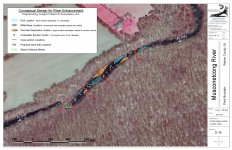
Unfortunately, if you were initially excited to see the Point Mountain TCA stream restoration project happen when it was first discussed a bunch of years ago, you, like me, now have a lot more gray hairs. But I am happy to say that the project is finally moving forward with the DEP working on our permit application. This is for the approx. 1/3 mile reach above the "S-Bend" where I first met SIMMS, in fact, upstream to the tight run well upstream where the river widens. See photos shot recently at a low 102 cfs.
Below: the "S-Bend" looking upstream at the flat water. Plan here is to build a boulder weir upstream and direct the flows flows around the bend and greatly deepen the pool at the bend to help dissipate energy in high flows while making deep pool habitat.

Below: Boulder weir to begin around where this large boulder is currently. I'm sure it (boulder) will be incorporated into this weir.

Below: Bad erosion from both high river flows and anglers stepping off the high banks. This will be less than a foot drop when we're done restoring a point/gravel bar here and planting native trees strategically to keep pressure off certain entry locations anglers currently use while making new ones that won't damage the banks nearly as much in the future.

Below: Currently crappy fishing water and bug water that won't remain crappy when we're done")

Below: More currently crappy water we want to fish better, and it will

Below: the top of the project looking downstream where the overly wide section is at its worst. We will deepen the tailout of the existing pool that ends just upstream of this shot that fishes great and begin moving the channel from here down nearly .33 miles, narrowing it and deepening it as we work from top to bottom. We will wind up with three new pools and improvements to other sections including some additional pocket water for those that love your high stick nymphing (and you all thought I was a dry fly snob).
Work to begin as soon as we get our DEP permit and water is low enough. We can't work in any year between March 15 - June 15 for trout stocking, so we hope to have this done long before that. Stay tuned for more details.

Funders: TU's Central Jersey Chapter, Trout & Salmon Foundation, Musconetcong River Management Council (part of the Wild & Scenic River program for this Partnership river which TU is a full partner), and grant funds I've raised from various sources. Thanks for the support of National Park Service for the Wild & Scenic support, US Fish & Wildlife Service, the NJ Division of Fish & Wildlife for support of both the project and for allowing us to do it on lands they own, and the support from Hunterdon County Parks and Recreation with whom we are also working on their lands as well as accessing the river on their property with a large track machine. And obviously, a big thanks to our important funders who have been waiting patiently for several years to see this project come to fruition.
Below: the "S-Bend" looking upstream at the flat water. Plan here is to build a boulder weir upstream and direct the flows flows around the bend and greatly deepen the pool at the bend to help dissipate energy in high flows while making deep pool habitat.
Below: Boulder weir to begin around where this large boulder is currently. I'm sure it (boulder) will be incorporated into this weir.
Below: Bad erosion from both high river flows and anglers stepping off the high banks. This will be less than a foot drop when we're done restoring a point/gravel bar here and planting native trees strategically to keep pressure off certain entry locations anglers currently use while making new ones that won't damage the banks nearly as much in the future.
Below: Currently crappy fishing water and bug water that won't remain crappy when we're done
Below: More currently crappy water we want to fish better, and it will
Below: the top of the project looking downstream where the overly wide section is at its worst. We will deepen the tailout of the existing pool that ends just upstream of this shot that fishes great and begin moving the channel from here down nearly .33 miles, narrowing it and deepening it as we work from top to bottom. We will wind up with three new pools and improvements to other sections including some additional pocket water for those that love your high stick nymphing (and you all thought I was a dry fly snob).
Work to begin as soon as we get our DEP permit and water is low enough. We can't work in any year between March 15 - June 15 for trout stocking, so we hope to have this done long before that. Stay tuned for more details.
Funders: TU's Central Jersey Chapter, Trout & Salmon Foundation, Musconetcong River Management Council (part of the Wild & Scenic River program for this Partnership river which TU is a full partner), and grant funds I've raised from various sources. Thanks for the support of National Park Service for the Wild & Scenic support, US Fish & Wildlife Service, the NJ Division of Fish & Wildlife for support of both the project and for allowing us to do it on lands they own, and the support from Hunterdon County Parks and Recreation with whom we are also working on their lands as well as accessing the river on their property with a large track machine. And obviously, a big thanks to our important funders who have been waiting patiently for several years to see this project come to fruition.