Future Fanatic
Nirvana
...flood watch remains in effect from 8 am edt this morning through late tonight...
The flood watch continues for
* portions of new york and northeast pennsylvania...including the following counties...in new york...broome...chemung... Chenango...cortland...delaware...madison...northern oneida... Onondaga...otsego...schuyler...seneca...southern cayuga... Southern oneida...steuben...sullivan...tioga...tompkins and yates. in northeast pennsylvania...bradford...lackawanna... Luzerne...northern wayne...pike...southern wayne...susquehanna and wyoming.
* from 8 am edt this morning through late tonight
* low pressure will track from virginia across pennsylvania and new york today and bring a round of heavy rain to central new york and northeast pennsylvania. The heaviest rain today is expected to occur from the upper mohawk valley...southwest across the finger lakes to the central southern tier of new york and also in bradford county pennsylvania. Rainfall of 3 to 5 inches is possible in these areas with locally higher amounts. Another low pressure system will track up the eastern seaboard tonight and focus heavier rains across the rest of northeast pennsylvania...the susquehanna region of new york and catskills. 3 to 5 inches of rain will be possible in the catskills with 1 to 3 inches expected across the rest of northeast pennsylvania and the susquehanna region of new york.
* the heavy rainfall will lead to the potential for significant flash flooding on small streams...creeks...urban...poor drainage and in low-lying areas. the highest threat for flash flooding will be across the higher terrain of the central southern tier and in the finger lakes and upper mohawk valley today. The threat will shift to the east later today and especially tonight for the catskills...poconos...northeast pennsylvania and the susquehanna region of new york.
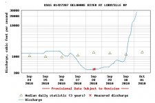
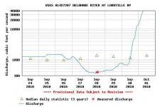
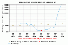
* the rainfall is expected to bring major rises on larger rivers in the chemung...delaware and susquehanna river basins. Rises of 1 to 3 feet will be possible on many of the finger lakes. At this time...it is too early to tell if any significant river or lake flooding will occur. If more rain falls than is currently expected at this time significant river or lake flooding will become more of a possibility.
Precautionary/preparedness actions...
A flood watch means that flooding of small streams...creeks and poor drainage areas is possible within the watch area. In addition flooding is also possible along larger rivers and the finger lakes. At this time it is too early to tell which areas will see flooding and how severe the flooding could become...especially along the larger rivers and lakes. People in the watch area should listen for later statements and possible flood warnings. Those living...working or driving in areas prone to flooding should be prepared to take action should flooding develop.
Listen to noaa weather radio or your local media for the later updates on this situation. You could also visit our website at NOAA's National Weather Service
The flood watch continues for
* portions of new york and northeast pennsylvania...including the following counties...in new york...broome...chemung... Chenango...cortland...delaware...madison...northern oneida... Onondaga...otsego...schuyler...seneca...southern cayuga... Southern oneida...steuben...sullivan...tioga...tompkins and yates. in northeast pennsylvania...bradford...lackawanna... Luzerne...northern wayne...pike...southern wayne...susquehanna and wyoming.
* from 8 am edt this morning through late tonight
* low pressure will track from virginia across pennsylvania and new york today and bring a round of heavy rain to central new york and northeast pennsylvania. The heaviest rain today is expected to occur from the upper mohawk valley...southwest across the finger lakes to the central southern tier of new york and also in bradford county pennsylvania. Rainfall of 3 to 5 inches is possible in these areas with locally higher amounts. Another low pressure system will track up the eastern seaboard tonight and focus heavier rains across the rest of northeast pennsylvania...the susquehanna region of new york and catskills. 3 to 5 inches of rain will be possible in the catskills with 1 to 3 inches expected across the rest of northeast pennsylvania and the susquehanna region of new york.
* the heavy rainfall will lead to the potential for significant flash flooding on small streams...creeks...urban...poor drainage and in low-lying areas. the highest threat for flash flooding will be across the higher terrain of the central southern tier and in the finger lakes and upper mohawk valley today. The threat will shift to the east later today and especially tonight for the catskills...poconos...northeast pennsylvania and the susquehanna region of new york.
* the rainfall is expected to bring major rises on larger rivers in the chemung...delaware and susquehanna river basins. Rises of 1 to 3 feet will be possible on many of the finger lakes. At this time...it is too early to tell if any significant river or lake flooding will occur. If more rain falls than is currently expected at this time significant river or lake flooding will become more of a possibility.
Precautionary/preparedness actions...
A flood watch means that flooding of small streams...creeks and poor drainage areas is possible within the watch area. In addition flooding is also possible along larger rivers and the finger lakes. At this time it is too early to tell which areas will see flooding and how severe the flooding could become...especially along the larger rivers and lakes. People in the watch area should listen for later statements and possible flood warnings. Those living...working or driving in areas prone to flooding should be prepared to take action should flooding develop.
Listen to noaa weather radio or your local media for the later updates on this situation. You could also visit our website at NOAA's National Weather Service