Welcome to NEFF

Sign up for a new account today, or log on with your old account!

Give us a try!

Welcome back to the new NEFF. Take a break from Twitter and Facebook. You don't go to Dicks for your fly fishing gear, you go to your local fly fishing store. Enjoy!

Ramapo River restoration is back on for Oakland

Rusty Spinner

Well-known member
I realize it has been years since we last talked about the mighty 'Po, but the Borough of Oakland has moved forward with a river restoration project for parts of the Ramapo running through the town starting most likely at Lenape Lane bridge and going downstream more than a mile to the RR trestle bridge. My firm is a subcontractor to the engineering firm (Dresdner Robin) that was hired, and we are doing the design once a freshwater mussel survey is completed. The presence of certain mussel species can significantly impact projects like these, and the mussels in question are in rough shape in a river that is "unwinding" due to man-made causes. We have identified 7-8 sites to create pool habitat and pocket water habitat over that 6,000+ feet section of the river. My firm will not perform the in-stream work (long story having to do with the newer NJ requirement for an Apprentice Program for our operators that makes zero sense for us), but we may wind up supervising the winning contractor so that the work is done correctly. Thought some here would appreciate the heads up.
 
This is good news. The Ramapo was once a fine trout stream, and could be again. I grew up in Franklin Lakes, but never fished there but once or twice. By the mid to late 70's when I got into fly fishing we went to north to Esopus Creek. Older fly fishing books like Trout by Bergman spoke highly of it and the Saddle River. I don't know the conditions in NY where it begins but a start is a start.
 
This is good news. The Ramapo was once a fine trout stream, and could be again. I grew up in Franklin Lakes, but never fished there but once or twice. By the mid to late 70's when I got into fly fishing we went to north to Esopus Creek. Older fly fishing books like Trout by Bergman spoke highly of it and the Saddle River. I don't know the conditions in NY where it begins but a start is a start.
Unfortunately, the Ramapo has suffered mightily at the hands of overdevelopment and those impacts will never be fully reversed. But that doesn't mean you do nothing. I had a funny issue on my Trout Scapes Facebook page today. Some ass-hat jumped all over me saying I he has "no trust and we have lost all credibility" because I wrote that I-287 is 8 lanes there when it is "only" actually 6. I was simply stating what a Borough of Oakland official had told me, it certainly wasn't a lie on my behalf. What I found most funny is the guy talking shit called me "rusty spinner", so he knows me most likely from this site. Gotta love the keyboard cowboys of the world, completely useless and never lift a finger to do anything other than complain. Rather than continuing arguing with a fool, I banned him and moved on. I love the internet! :D
 
The number of lanes depends on where you are and how you count them.
Where 208N merges with 287S, you can briefly add two lanes.
The way they suddenly disappear can be a bit of a traffic hazard if you're not ready for it.
Whether you consider them part of 208 or 287, or just merge lanes, is irrelevant... Watch your back, somebody's going to cut you off.
 
That is a bad ass merge onto 208, and I have to get off at Colonial Road, which is double bad ass. As far as the idiot that wanted to argue about the number of lanes, they must have a pretty dull life. Good work on the Ramapo. Think about how bad some streams were 50 years ago, and how some are doing well now. The work done there is worth it, it will be better. Now you got to get rid of that lake that dumps the warm water in there. Also, there are a couple of big springs that dump into there in Oakland with good cold water.
 
That is a bad ass merge onto 208, and I have to get off at Colonial Road, which is double bad ass. As far as the idiot that wanted to argue about the number of lanes, they must have a pretty dull life. Good work on the Ramapo. Think about how bad some streams were 50 years ago, and how some are doing well now. The work done there is worth it, it will be better. Now you got to get rid of that lake that dumps the warm water in there. Also, there are a couple of big springs that dump into there in Oakland with good cold water.
There is talk about removing the dams on Alerman Brook (spelling?) which would end Crystal Lake for good and all the problems it has with sediment accumulation.
 
There is talk about removing the dams on Alerman Brook (spelling?) which would end Crystal Lake for good and all the problems it has with sediment accumulation.
The current plan is to sell Mirror Lake and adjacent lots to whoever will buy them. What happens then is between the new owner, the DEP, and the zoning people.

They're currently negotiating with a potential HOA consisting of lakeside residents, who want to "save" Crystal Lake. The profits from the sale of Mirror Lake may be used to repair the spillway.

The Lake Club/Beach is being sold separately to a newly formed non-profit. I believe it's currently in escrow.

I'd love to see the Brook restored to it's pre-1900s state, but I don't think it's going to happen.

Re Spelling: Allerman has two Ls, but every mapmaker, neighboring Franklin Lakes, and the DPW call it "Pond Brook".
 
Last edited:
Pete, that is interesting and I might have some insight on why that is called Pond Brook. I believe this is the brook that crosses 202 just over from the intersection of Long Hill Rd/Franklin Lakes Rd. A long long time ago-maybe 40 years-I was actually young. And I went to house up the hill on Long Hill/Franklin Lakes Rd-and that house had a pond. It was on the left as you head toward FL, and was back in off the road a ways. I was there in July or August. I saw fish in the pond, and got my fly rod out, and caught a beautiful little brook trout. There were many there. It was cold water, and obviously spring fed. This the brook that would go by the old Pleasureland, correct? Anyway, if that is it, it is probably why it is called Pond Brook. And there are probably still some brook trout in it.
 
Greg:
The brook along Long Hill Road is "Little Pond Brook". It's very small, but it's one of the few TP streams in the Ramapo drainage producing more than one species of trout.... Yes it enters the Ramapo in the former Pleasureland Park (now part of Great Oak Park).

"Pond Brook" starts as a source of the Franklin Lake, flows through the lake, and then north along High Mountain Road, turns west at the Railroad tracks, and ends up entering the Ramapo at the Crystal Lake spillway.... In Oakland, it's also known locally as Allerman Brook.... It's feeder streams drain most of western Franklin Lakes, and a portion of eastern Oakland, including runoff from 208/287.

As to the names... Before all the local neighborhoods formed independent Boroughs, Franklin Township was huge with descriptive local place names. The area just to the west of Pond Brook was known as "The Ponds". One of those ponds is quite near the sources of Little Pond Brook.
The local "Allerman Brook" name appears to be the result of Pond Brook passing through or near a former farm owned by the Allerman family.
 
Last edited:
Unfortunately, the Ramapo has suffered mightily at the hands of overdevelopment and those impacts will never be fully reversed. But that doesn't mean you do nothing. I had a funny issue on my Trout Scapes Facebook page today. Some ass-hat jumped all over me saying I he has "no trust and we have lost all credibility" because I wrote that I-287 is 8 lanes there when it is "only" actually 6. I was simply stating what a Borough of Oakland official had told me, it certainly wasn't a lie on my behalf. What I found most funny is the guy talking shit called me "rusty spinner", so he knows me most likely from this site. Gotta love the keyboard cowboys of the world, completely useless and never lift a finger to do anything other than complain. Rather than continuing arguing with a fool, I banned him and moved on. I love the internet! :D
This is BS, Rusty. I think you have more than enough credibility to be subcontractor to the subcontractor on this project.

If you'd known the number of lanes, I might even say you'd be qualified to perform work in the stream but as it stands we'd all feel more comfortable with you "holding the proverbial flashlight" in more of a "weekend, assistant manager" capacity.
 
Hi Pete-thanks for clearing that up. I am very familiar with Pond Brook(not the name, the brook itself) as I grew up in FL-on High Mt Road. Little Pond Brook is definitely the one that I was referencing. And now I know where the local term and one time sporting goods store The Ponds came from.
 
Hi Pete-thanks for clearing that up. I am very familiar with Pond Brook(not the name, the brook itself) as I grew up in FL-on High Mt Road. Little Pond Brook is definitely the one that I was referencing. And now I know where the local term and one time sporting goods store The Ponds came from.
I grew up on the other side of Franklin Lakes. Before I was old enough to drive, I did most of my fishing in the headwaters of the Ho-Ho-Kus Brook watershed.
 
One concern about this project is the presence of a federally listed freshwater mussel which is struggling mightily in this river. Their numbers have dropped precipitously the last few years and it doesn't look for now like they will impact our design which is a positive.
 
I grew up on the other side of Franklin Lakes. Before I was old enough to drive, I did most of my fishing in the headwaters of the Ho-Ho-Kus Brook watershed.

I'm a 70's FL kid(the best time to grow up). I did all of mine in Franklin Lake. Went to Ramapo. You too?

Rusty, how many different freshwater mussels are there in NJ? Are they the same as those found in lakes? I know nothing about freshwater mussels, other than digging them up as a kid in the lake bottom.
 
Greg - 1950s, it was an entirely different town before 208 was completed and made it "commutable". I was in the Ramapo class of 1961, the first class to spend the entire four years there. When I returned in 1967 (after college and the Army), it was no longer "the sticks", but an upscale suburb filled with rich people.
 
Hi Pete-that's around when we moved there(68). You think it was wealthy then, drive around today. But it was still good then, camping and hunting on High Mountain when the woods stretched all the way to Wayne.....
 
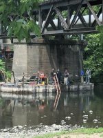
Somebody posted a picture of the downstream end of the project in the OaklandNJ Facebook group.
There was some speculation...
Did Brian gain some weight? :D

1717595335701.jpeg
 
If memory serves, there's a riffle just upstream of the RR bridge that we would enhance and that would be the final site for any restoration. Below is Army Corps project sites and I don't touch their work with a 10 foot pole as my late father was fond of saying. That agency screws up every project they touch. But at least they take far too many years developing those projects at significant taxpayer expense, so there's that....
 
That agency screws up every project they touch. But at least they take far too many years developing those projects at significant taxpayer expense, so there's that....
Well isn't that the truth. But is that really different than any other government bureaucracy?
 
Actually, the Corps flood control project was very successful in moving the problem downstream. Good for the "Colony" section of Oakland, but a disaster for parts of Wayne and Pompton Lakes....
 
Actually, the Corps flood control project was very successful in moving the problem downstream. Good for the "Colony" section of Oakland, but a disaster for parts of Wayne and Pompton Lakes....
The flood control they built in your town makes no sense to me. They should have bypassed Potash Lake and drained it so that it can provide flood storage capacity when it rains hard. The mighty 'Po lacks sufficient floodplain capacity. I did notice a lot of homes on the river in places now condemned and empty. I hear they are being razed soon. There are four at Lenape Lane, for example that are all abandoned.
 
When I was younger many of those houses would flood every few years, it would be on the news with video etc. That is an example of how the FEMA flood insurance program encouraged building and living in what are probably 5 or 10 year flood plains. Pete will know about this also. Everybody was paying them to continue living there. I do know they were bought out or something like that, it could have been in the wake of Hurricane Sandy, when flood insurance changed in a big way.
 
When I was younger many of those houses would flood every few years, it would be on the news with video etc. That is an example of how the FEMA flood insurance program encouraged building and living in what are probably 5 or 10 year flood plains. Pete will know about this also. Everybody was paying them to continue living there. I do know they were bought out or something like that, it could have been in the wake of Hurricane Sandy, when flood insurance changed in a big way.
Blue Acres is what the town is using which is part of the Green Acres program. The Blue Acres dollars pay for buying homes and businesses in flood prone areas and bulldozing them like the ones off Roosevelt Blvd. by Truman Fields. Hurricane Irene was the flood of record and the one that really highlighted the issues, Sandy was only a wind event here. It flooded the low lying shore areas, but it wasn't a rain event for northern NJ. But I hear you on the FEMA insurance.
 
Thanks for that, I had never heard of blue acres! I have lived in south Jersey for 40 years now, forcing long travel to fish and ignorance of Oakland and Ramapo river matters. But I hope the stream improves. It would be good for the area in many ways.
 
When I was younger many of those houses would flood every few years, it would be on the news with video etc. That is an example of how the FEMA flood insurance program encouraged building and living in what are probably 5 or 10 year flood plains. Pete will know about this also. Everybody was paying them to continue living there. I do know they were bought out or something like that, it could have been in the wake of Hurricane Sandy, when flood insurance changed in a big way.
Most of those homes were built before 1960 when 208 (with it's runoff) was completed. The subsequent building boom created even more impervious surfaces. After 287 was added to the mix "100 year floods" were happening every few years.

The areas associated with The Colony, Crystal Lake, Sandy Beach, Pleasureland, & etc, were just summer bungalows. Now they're year-round homes.

When the "Blue Acres" money became available, lawyers were showing up at Council meetings, threatening to sue because their client(s) weren't included.
 
Last edited:
Most of those homes were built before 1960 when 208 (with it's runoff) was completed. The subsequent building boom created even more impervious surfaces. After 287 was added to the mix "100 year floods" were happening every few years.

The areas associated with The Colony, Crystal Lake, Sandy Beach, Pleasureland, & etc, were just summer bungalows. Now they're year-round homes.

When the "Blue Acres" money became available, lawyers were showing up a Council meetings, threatening to sue because their client(s) weren't included.
That one development built on the hill above Glen Gray Road and Patriots Way was an abomination from a storm water standpoint. I purposely went there during a good rain storm and witnessed most of the water flowing down the road and not into stormwater drains. The grading was improper to move water towards those. As a result, super heated (in summer) water rushes fast downhill on asphalt and directly into the river with virtually nothing slowing it down or cooling it off. Seems a few adjustments to pavement near the stormwater drains would greatly improve their functioning and sending the water into stormwater retention basins to meter out slowly into the river rather than rushing in unimpeded.
 
That one development built on the hill above Glen Gray Road and Patriots Way was an abomination from a storm water standpoint. I purposely went there during a good rain storm and witnessed most of the water flowing down the road and not into stormwater drains. The grading was improper to move water towards those. As a result, super heated (in summer) water rushes fast downhill on asphalt and directly into the river with virtually nothing slowing it down or cooling it off. Seems a few adjustments to pavement near the stormwater drains would greatly improve their functioning and sending the water into stormwater retention basins to meter out slowly into the river rather than rushing in unimpeded.
Most of that development is a violation of the Boroughs "steep slope" ordinance.
So the developer included some "Affordable Housing", to get the courts to override the ordinance.

An unnamed brook that runs through that development is supposedly a TP stream. I doubt if there's much left but (maybe) one branch of the headwaters.
 
This is somewhat off topic but mention of that area brings back memories for me. When I was a teenager, about 70years ago I often fished I think was Bear Swamp brook which paralelled the road leading to Camp Yaw Paw. At that time there was a healthy population of brookies there. I also spent several Summers at the Glen Gray boy scout camp but never fished the brook that ran next to the road to Glen Gray. Wondering how all that has changed over the years. I believe both boy scout camps have long since closed.
 
Back
Top