
Joe D
Registered User
<table align="center" border="0" cellpadding="3" cellspacing="3" width="750"><tbody><tr><td align="left" width="100%">Fisheries Management personnel from the Area 8 office in Somerset with assistance from interns from the 3 Rivers Ecological Research Center and biologists from the Somerset County Conservation District, surveyed 15 unassessed waters in the Laurel Hill Creek and Big Sandy Creek basins in Somerset and Fayette Counties. The surveys were conducted as part of a concentrated statewide effort to document wild trout waters throughout the Commonwealth that had not been previously surveyed. Using GIS technologies, streams with the potential to hold wild trout and that were also facing pressure from human influences were identified as candidates to sample. Sampling was conducted using backpack electrofishing gear during June and July 2009. Table 1 below lists the streams sampled and whether or not wild trout were determined to be present in the streams. Table 1. Unassessed streams in the Big Sandy and Laurel Hill Creek basins surveyed during the summer of 2009.
<table align="center" border="0" cellpadding="3" cellspacing="0" width="90%"> <tbody><tr class="gray"> <td nowrap="nowrap" valign="bottom">Basin
</td> <td nowrap="nowrap" valign="bottom">Stream Name
</td> <td nowrap="nowrap" valign="bottom">Latitude/Longitude of Mouth
</td> <td nowrap="nowrap" valign="bottom">Wild Trout Documented
</td> </tr> <tr> <td nowrap="nowrap" valign="bottom">Big Sandy Creek
</td> <td nowrap="nowrap" valign="bottom">Stony Fork
</td> <td nowrap="nowrap" valign="bottom">39 45 58 / 79 37 28
</td> <td nowrap="nowrap" valign="bottom">No
</td> </tr> <tr> <td nowrap="nowrap" valign="bottom">Big Sandy Creek
</td> <td nowrap="nowrap" valign="bottom">Scotts Run
</td> <td nowrap="nowrap" valign="bottom">39 47 44 / 79 37 02
</td> <td nowrap="nowrap" valign="bottom">No
</td> </tr> <tr> <td nowrap="nowrap" valign="bottom">Big Sandy Creek
</td> <td nowrap="nowrap" valign="bottom">McIntire Run
</td> <td nowrap="nowrap" valign="bottom">39 47 30 / 79 37 06
</td> <td nowrap="nowrap" valign="bottom">Yes
</td> </tr> <tr> <td nowrap="nowrap" valign="bottom">Big Sandy Creek
</td> <td nowrap="nowrap" valign="bottom">Patterson Run
</td> <td nowrap="nowrap" valign="bottom">39 43 15 / 79 44 52
</td> <td nowrap="nowrap" valign="bottom">Yes
</td> </tr> <tr> <td nowrap="nowrap" valign="bottom">Big Sandy Creek
</td> <td nowrap="nowrap" valign="bottom">UNT to Little Sandy Creek
</td> <td nowrap="nowrap" valign="bottom">39 44 22 / 79 35 31
</td> <td nowrap="nowrap" valign="bottom">No
</td> </tr> <tr> <td nowrap="nowrap" valign="bottom">Big Sandy Creek
</td> <td nowrap="nowrap" valign="bottom">UNT to Little Sandy Creek
</td> <td nowrap="nowrap" valign="bottom">39 45 02 / 79 34 30
</td> <td nowrap="nowrap" valign="bottom">No
</td> </tr> <tr> <td nowrap="nowrap" valign="bottom">Laurel Hill Creek
</td> <td nowrap="nowrap" valign="bottom">Mose King Run
</td> <td nowrap="nowrap" valign="bottom">39 54 17 / 79 18 58
</td> <td nowrap="nowrap" valign="bottom">No
</td> </tr> <tr> <td nowrap="nowrap" valign="bottom">Laurel Hill Creek
</td> <td nowrap="nowrap" valign="bottom">Gross Run
</td> <td nowrap="nowrap" valign="bottom">40 01 45 / 79 13 21
</td> <td nowrap="nowrap" valign="bottom">Yes
</td> </tr> <tr> <td nowrap="nowrap" valign="bottom">Laurel Hill Creek
</td> <td nowrap="nowrap" valign="bottom">Crab Run
</td> <td nowrap="nowrap" valign="bottom">39 59 07 / 79 15 36
</td> <td nowrap="nowrap" valign="bottom">Yes
</td> </tr> <tr> <td nowrap="nowrap" valign="bottom">Laurel Hill Creek
</td> <td nowrap="nowrap" valign="bottom">Spruce Run
</td> <td nowrap="nowrap" valign="bottom">39 59 16 / 79 14 31
</td> <td nowrap="nowrap" valign="bottom">Yes
</td> </tr> <tr> <td nowrap="nowrap" valign="bottom">Laurel Hill Creek
</td> <td nowrap="nowrap" valign="bottom">Whipkey Run
</td> <td nowrap="nowrap" valign="bottom">39 54 41 / 79 18 21
</td> <td nowrap="nowrap" valign="bottom">Yes
</td> </tr> <tr> <td nowrap="nowrap" valign="bottom">Laurel Hill Creek
</td> <td nowrap="nowrap" valign="bottom">Paddytown Hollow
</td> <td nowrap="nowrap" valign="bottom">39 50 40 / 79 18 47
</td> <td nowrap="nowrap" valign="bottom">Yes
</td> </tr> <tr> <td nowrap="nowrap" valign="bottom">Laurel Hill Creek
</td> <td nowrap="nowrap" valign="bottom">Smith Hollow
</td> <td nowrap="nowrap" valign="bottom">39 51 22 / 79 19 11
</td> <td nowrap="nowrap" valign="bottom">Yes
</td> </tr> <tr> <td nowrap="nowrap" valign="bottom">Laurel Hill Creek
</td> <td nowrap="nowrap" valign="bottom">Crise Run
</td> <td nowrap="nowrap" valign="bottom">40 01 43 / 79 13 21
</td> <td nowrap="nowrap" valign="bottom">No
</td> </tr> <tr> <td nowrap="nowrap" valign="bottom">Laurel Hill Creek
</td> <td nowrap="nowrap" valign="bottom">UNT to Cranberry Glade Run
</td> <td nowrap="nowrap" valign="bottom">39 54 03 / 79 22 06
</td> <td nowrap="nowrap" valign="bottom">No
</td> </tr> </tbody></table> Out of the 15 streams surveyed, eight streams were documented as having wild trout. Many of the streams surveyed do not support fishable wild trout populations, but possess water quality and habitat suitable for wild trout. Also, many are located on private property and landowner permission must be acquired before angling is considered.
As the GIS methodology used to identify unassessed waters focused on encroachment by humans in a watershed, biologists made note of all stressors present in the streams that were sampled. As evidenced in the pictures below, sediment from runoff is just one of the major forms of pollutants that can severely impact a wild trout population. The brook trout pictured below is one of just a handful of fish captured in a stream with a severe sediment problem. Sediment can cover trout spawning redds and prevent trout reproduction from occurring, with negative effects on the wild trout population.
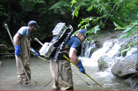
Sampling a pool on a Laurel Hill Creek tributary
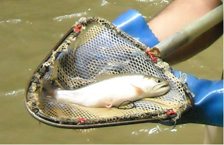
Native brook trout from a Laurel Hill Creek tributary. Heavy siltation from runoff has stained the water and reduced the wild trout population, despite what appears to be ideal habitat. Interestingly, the stained water also reduces the natural coloration of the wild brook trout.</td> </tr> <tr> <td align="right" width="100%">
</td> </tr> <tr> <td align="right" width="100%">– Prepared by Area 8 Fisheries Biologist Mike Depew</td></tr></tbody></table>
<table align="center" border="0" cellpadding="3" cellspacing="0" width="90%"> <tbody><tr class="gray"> <td nowrap="nowrap" valign="bottom">Basin
</td> <td nowrap="nowrap" valign="bottom">Stream Name
</td> <td nowrap="nowrap" valign="bottom">Latitude/Longitude of Mouth
</td> <td nowrap="nowrap" valign="bottom">Wild Trout Documented
</td> </tr> <tr> <td nowrap="nowrap" valign="bottom">Big Sandy Creek
</td> <td nowrap="nowrap" valign="bottom">Stony Fork
</td> <td nowrap="nowrap" valign="bottom">39 45 58 / 79 37 28
</td> <td nowrap="nowrap" valign="bottom">No
</td> </tr> <tr> <td nowrap="nowrap" valign="bottom">Big Sandy Creek
</td> <td nowrap="nowrap" valign="bottom">Scotts Run
</td> <td nowrap="nowrap" valign="bottom">39 47 44 / 79 37 02
</td> <td nowrap="nowrap" valign="bottom">No
</td> </tr> <tr> <td nowrap="nowrap" valign="bottom">Big Sandy Creek
</td> <td nowrap="nowrap" valign="bottom">McIntire Run
</td> <td nowrap="nowrap" valign="bottom">39 47 30 / 79 37 06
</td> <td nowrap="nowrap" valign="bottom">Yes
</td> </tr> <tr> <td nowrap="nowrap" valign="bottom">Big Sandy Creek
</td> <td nowrap="nowrap" valign="bottom">Patterson Run
</td> <td nowrap="nowrap" valign="bottom">39 43 15 / 79 44 52
</td> <td nowrap="nowrap" valign="bottom">Yes
</td> </tr> <tr> <td nowrap="nowrap" valign="bottom">Big Sandy Creek
</td> <td nowrap="nowrap" valign="bottom">UNT to Little Sandy Creek
</td> <td nowrap="nowrap" valign="bottom">39 44 22 / 79 35 31
</td> <td nowrap="nowrap" valign="bottom">No
</td> </tr> <tr> <td nowrap="nowrap" valign="bottom">Big Sandy Creek
</td> <td nowrap="nowrap" valign="bottom">UNT to Little Sandy Creek
</td> <td nowrap="nowrap" valign="bottom">39 45 02 / 79 34 30
</td> <td nowrap="nowrap" valign="bottom">No
</td> </tr> <tr> <td nowrap="nowrap" valign="bottom">Laurel Hill Creek
</td> <td nowrap="nowrap" valign="bottom">Mose King Run
</td> <td nowrap="nowrap" valign="bottom">39 54 17 / 79 18 58
</td> <td nowrap="nowrap" valign="bottom">No
</td> </tr> <tr> <td nowrap="nowrap" valign="bottom">Laurel Hill Creek
</td> <td nowrap="nowrap" valign="bottom">Gross Run
</td> <td nowrap="nowrap" valign="bottom">40 01 45 / 79 13 21
</td> <td nowrap="nowrap" valign="bottom">Yes
</td> </tr> <tr> <td nowrap="nowrap" valign="bottom">Laurel Hill Creek
</td> <td nowrap="nowrap" valign="bottom">Crab Run
</td> <td nowrap="nowrap" valign="bottom">39 59 07 / 79 15 36
</td> <td nowrap="nowrap" valign="bottom">Yes
</td> </tr> <tr> <td nowrap="nowrap" valign="bottom">Laurel Hill Creek
</td> <td nowrap="nowrap" valign="bottom">Spruce Run
</td> <td nowrap="nowrap" valign="bottom">39 59 16 / 79 14 31
</td> <td nowrap="nowrap" valign="bottom">Yes
</td> </tr> <tr> <td nowrap="nowrap" valign="bottom">Laurel Hill Creek
</td> <td nowrap="nowrap" valign="bottom">Whipkey Run
</td> <td nowrap="nowrap" valign="bottom">39 54 41 / 79 18 21
</td> <td nowrap="nowrap" valign="bottom">Yes
</td> </tr> <tr> <td nowrap="nowrap" valign="bottom">Laurel Hill Creek
</td> <td nowrap="nowrap" valign="bottom">Paddytown Hollow
</td> <td nowrap="nowrap" valign="bottom">39 50 40 / 79 18 47
</td> <td nowrap="nowrap" valign="bottom">Yes
</td> </tr> <tr> <td nowrap="nowrap" valign="bottom">Laurel Hill Creek
</td> <td nowrap="nowrap" valign="bottom">Smith Hollow
</td> <td nowrap="nowrap" valign="bottom">39 51 22 / 79 19 11
</td> <td nowrap="nowrap" valign="bottom">Yes
</td> </tr> <tr> <td nowrap="nowrap" valign="bottom">Laurel Hill Creek
</td> <td nowrap="nowrap" valign="bottom">Crise Run
</td> <td nowrap="nowrap" valign="bottom">40 01 43 / 79 13 21
</td> <td nowrap="nowrap" valign="bottom">No
</td> </tr> <tr> <td nowrap="nowrap" valign="bottom">Laurel Hill Creek
</td> <td nowrap="nowrap" valign="bottom">UNT to Cranberry Glade Run
</td> <td nowrap="nowrap" valign="bottom">39 54 03 / 79 22 06
</td> <td nowrap="nowrap" valign="bottom">No
</td> </tr> </tbody></table> Out of the 15 streams surveyed, eight streams were documented as having wild trout. Many of the streams surveyed do not support fishable wild trout populations, but possess water quality and habitat suitable for wild trout. Also, many are located on private property and landowner permission must be acquired before angling is considered.
As the GIS methodology used to identify unassessed waters focused on encroachment by humans in a watershed, biologists made note of all stressors present in the streams that were sampled. As evidenced in the pictures below, sediment from runoff is just one of the major forms of pollutants that can severely impact a wild trout population. The brook trout pictured below is one of just a handful of fish captured in a stream with a severe sediment problem. Sediment can cover trout spawning redds and prevent trout reproduction from occurring, with negative effects on the wild trout population.
Sampling a pool on a Laurel Hill Creek tributary
Native brook trout from a Laurel Hill Creek tributary. Heavy siltation from runoff has stained the water and reduced the wild trout population, despite what appears to be ideal habitat. Interestingly, the stained water also reduces the natural coloration of the wild brook trout.
</td> </tr> <tr> <td align="right" width="100%">– Prepared by Area 8 Fisheries Biologist Mike Depew</td></tr></tbody></table>