thrashers.wheat
New member
Drove over 2 hours from the closest gas station - camped at a very primitive spot within a few miles of a ridge that separates two of the finest freshwater fishing states in our nation. The road leading to the trailhead was spectacular. I had never seen so many huckleberries than I have in this area. I did spot two moose, a cow and it's calf...The cow took off, man, when it saw my truck. Such a powerful animal...The calf trotted up the road and more cooperative for a photo. Photo is very blurry for some reason...

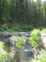
Just past the moose was the primitive trailhead...A nice wooden sign indicating the trail branches I viewed on the topo while scouting this primitive area. The trail started on the ***** ridge trail...Being on the ridge, I could look down to the left & right of myself to what appeared to be near vertical ledges, it was sweet. About a mile in, I got to a trail marker indicating the river was still 5 miles away. So, a 6 mile hike featuring over 2200' feet in elevation. Hiking out was flat out tough...

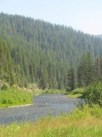
what the river looked like when I got to it. The trout were not nearly as plentiful as I've found them further downstream, but were still very active and scrappy fighters in this creekish section of this national wild, and scenic river.

Each spot seemed to have a fish or two, I think my biggest cutty was about 12".

Two rods...One with a dry dropper, the other rigged with a tandem nymph rig. Nymphing, was by far, the best bet, although I did get some nice fish on dries. This usually seems to be the case in this region during August.

Clear water...The plunge pool here was about 8' deep. There was some sort of duck? on top of the rock. The bird was all by itself. I thought merganser, but did look differently than the merganser's I've seen in the past.

Fish on down river.
It was slow on this stream this year. It was hot, late in the season and crowded. We did figure that the fires throughout the region caused people to visit this area, which was not affected by smoke. Also, there was dust abatement work being conducted on the roads around the river with workers camped at various spots along the river. My Aunt & Uncle stayed an extra week and did see some clouds & rain, and said the fishing came alive once the front hit the area.
Just past the moose was the primitive trailhead...A nice wooden sign indicating the trail branches I viewed on the topo while scouting this primitive area. The trail started on the ***** ridge trail...Being on the ridge, I could look down to the left & right of myself to what appeared to be near vertical ledges, it was sweet. About a mile in, I got to a trail marker indicating the river was still 5 miles away. So, a 6 mile hike featuring over 2200' feet in elevation. Hiking out was flat out tough...
what the river looked like when I got to it. The trout were not nearly as plentiful as I've found them further downstream, but were still very active and scrappy fighters in this creekish section of this national wild, and scenic river.
Each spot seemed to have a fish or two, I think my biggest cutty was about 12".
Two rods...One with a dry dropper, the other rigged with a tandem nymph rig. Nymphing, was by far, the best bet, although I did get some nice fish on dries. This usually seems to be the case in this region during August.
Clear water...The plunge pool here was about 8' deep. There was some sort of duck? on top of the rock. The bird was all by itself. I thought merganser, but did look differently than the merganser's I've seen in the past.
Fish on down river.
It was slow on this stream this year. It was hot, late in the season and crowded. We did figure that the fires throughout the region caused people to visit this area, which was not affected by smoke. Also, there was dust abatement work being conducted on the roads around the river with workers camped at various spots along the river. My Aunt & Uncle stayed an extra week and did see some clouds & rain, and said the fishing came alive once the front hit the area.