Welcome to NEFF

Sign up for a new account today, or log on with your old account!

Give us a try!

Welcome back to the new NEFF. Take a break from Twitter and Facebook. You don't go to Dicks for your fly fishing gear, you go to your local fly fishing store. Enjoy!

Bushkill Stream restoration news

Rusty Spinner

Active member
I've been working with the Forks of the Delaware TU chapter while I was on staff and more recently now that I'm with Urbani Fisheries to restore a nearly 2 mile reach of the Bushkill Stream above Binney & Smith. Looks like the TU chapter and their partners at the Bushkill Stream Conservancy have received the final approvals they need to move forward with this project. I have been very impressed at the support these two groups have received from the landowners as well as PA DEP, Boat & Fish Commission, and the county soil conservation district. I look forward to restoring a trout river in PA which is all public access and wild browns. Let's hope the project continues to move smoothly forward.

Palmer Township supports Bushkill Creek restoration project - The Morning Call
 
Rusty, what do you figure will be the upstream boundary of the restoration?

There's a public ball field next to the main street (route 1002) bridge in Tatamy. The cross street is Buskkill Street. Figure approximately 1 3/4 miles downstream from that point which covers parts of 3 different towns and Lafayette College as well as a couple of private properties on river right looking downstream.
 
There's a public ball field next to the main street (route 1002) bridge in Tatamy. The cross street is Buskkill Street. Figure approximately 1 3/4 miles downstream from that point which covers parts of 3 different towns and Lafayette College as well as a couple of private properties on river right looking downstream.

That's the sweet spot. I had heard that would be the section but got a little confused when you mentioned above Binney & Smith.
 
That's the sweet spot. I had heard that would be the section but got a little confused when you mentioned above Binney & Smith.

Am I wrong? I really don't know that river well yet. I'm thinking that the Crayola factory is further downstream. I know this is downstream from the quarry that at times de-waters the river. I know that the target species is wild browns and we can do some wonderful things for that species in this reach. PA DEP wants us to add woody debris and there are some monster trees already on point bars complete with root wads I want to jam in the banks where we deepen pools. There are two tricky spots where ledge rock is just above a bridge and that bridge has a center pier with a long, slow pool below, but we can deal with that when the time comes.

I just wish the banks weren't so built up to prevent flooding as the river can't get into its floodplain properly during flood events. That means some extra work for us and some huge boulders that won't move in floods with all that energy remaining in the channel, but we can't fix the floodplain access issues.
 
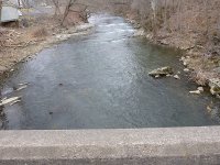
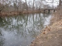
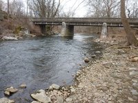
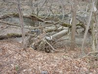
Some pix from the proposed restoration project:


(below) Bridge looking upstream at ledge rock. This bridge has a center pier which makes our work a bit more tricky in this spot.
Streamkill bridge and upstream ledgerock resized.jpg

(below) Same bridge looking upstream and the bridge pool below that is a bit too slow and wide now.
Bushkill bridge pool looking up resized.jpg

(below) Same bridge with close up of the thalweg hitting the center pier.
Bushkill bridge resized.jpg


(below) Woody debris we can use as habitat in deepened pools.
Bushkill tree root wad resized.jpg
 
Am I wrong? I really don't know that river well yet. I'm thinking that the Crayola factory is further downstream. I know this is downstream from the quarry that at times de-waters the river. I know that the target species is wild browns and we can do some wonderful things for that species in this reach. PA DEP wants us to add woody debris and there are some monster trees already on point bars complete with root wads I want to jam in the banks where we deepen pools. There are two tricky spots where ledge rock is just above a bridge and that bridge has a center pier with a long, slow pool below, but we can deal with that when the time comes.

I just wish the banks weren't so built up to prevent flooding as the river can't get into its floodplain properly during flood events. That means some extra work for us and some huge boulders that won't move in floods with all that energy remaining in the channel, but we can't fix the floodplain access issues.

Binney is Crayola and that would be down where the No Kill starts. It's probably about 4 miles from Tatamy 1002 bridge to just above the dam at Binney. That rock ledge is behind the Farm Co-op, just above the bridge. I really would like to see what you have in store for the Spring House to Newlins section. Right now there is a lot of nothing water that could use some TLC.
 
Binney is Crayola and that would be down where the No Kill starts. It's probably about 4 miles from Tatamy 1002 bridge to just above the dam at Binney. That rock ledge is behind the Farm Co-op, just above the bridge. I really would like to see what you have in store for the Spring House to Newlins section. Right now there is a lot of nothing water that could use some TLC.

PM me your email or shoot me one at: BCowden@urbanifisheries.com I can show you our conceptual design, but it is only conceptual and not the full 1 3/4 mile. I can't post it as a PDF here. We wouldn't have a formal design until they get the last private owner(s) on board and then hire us to do a survey which leads to our design.
 
sounds like an interesting job. Nothing more rewarding than seeing results for your hard work.
 
It will be nice to see that stretch get some help. I used to fish it a lot. The sulphers by that fa bureau bridge were great and more then a few big browns were caught by that middle abutment. That slow water down below was always a good trico spot for me,and there used to be a big tree at the tail out in the water that held sole bruisers. I fished there after the first dewatering and was suprised how well the fish had come back. I haven't been back since the last dewatering. Is there any plans to keep this from happening again? That water does warm a bit because most of the springs don't come into the bushkill till you hit stockertown. I may hit it this year for tricos if temps are good. There is a lot of good stretches on the bushkill that could use some help. In its hey day pa electro shocked a 330 yard stretch and came up with 1500 fish. That's was down below crayola. The last shocking didn't get enough fish to maintain the class a status. I would love to see that creek returned to its former glory. Can't wait to see the plans,and some progress. Thanks.
 
TM, I mentioned to FIN-ITE 34 that I think there are some folks working on stream flows, but that is outside the scope of my project. You can ask the Bushkill Stream Conservancy or the Forks of the Delaware TU chapter for better info on that.

I bet that pool below the bridge is great trico water and it should still be after our project. I just want to tighten up the width and cut off that one back channel from normal flows. We would also redirect the thalweg under the bridge so it does a better job scouring the top of that pool and sending sediment downstream while improving DO.

Is this that log? It's at the bottom of the long pool currently.

.Bushkill big log at pool bottom resized.jpg
 
Rusty,that looks like it but it was in the water at a 45 degree angle and the water flowed under it and made a deep cut. The fish I used to catch were spectacular. Do me one favor if the satellite dish is still in th sharp bend up stream leave it. Some nice trout lived under that thing but the drift was tough:)
 
Rusty,that looks like it but it was in the water at a 45 degree angle and the water flowed under it and made a deep cut. The fish I used to catch were spectacular. Do me one favor if the satellite dish is still in th sharp bend up stream leave it. Some nice trout lived under that thing but the drift was tough:)


Too funny. Didn't notice it, but that doesn't mean it's not still there. Re: the log, I bet this is the one as it is completely water logged, but the river has shoaled where it is located due in part to channelization and the build up of the banks to thwart flooding as well as that darned bridge pier and some historic flows in events like Irene.
 
I can't believe how much that downstream section has changed after giving your pic a closer look. The tail of that pool used to shallow into a riffle and would sweep left around and under that log it then would hit the left bank forming a nice deep run where I always found risers,then it would straighten out. That right channel and that little island were never there,that was all bank.
 
I can't believe how much that downstream section has changed after giving your pic a closer look. The tail of that pool used to shallow into a riffle and would sweep left around and under that log it then would hit the left bank forming a nice deep run where I always found risers,then it would straighten out. That right channel and that little island were never there,that was all bank.

Thanks for that info. That's the kind of thing that is very helpful along with older aerial photos to get an idea of how best to restore a damaged reach to its former glory. Sometimes I get lucky and meet lots of anglers and neighbors that can give me great background and other times I have to make educated guesses.

(and if the satellite dish is missing, we'll put one back in there)
 
Rusty,I can probably draw u a detailed map of how it was when I fished it. From the ballfield bridge down to the end of the long slow pool. I can even put fish locations in for you. O used to get a lot of washed down rainbows in the upper area in the ledges behind the ballfield. The olives were epic in that stretch.
 
There are no wild trout there and the ones they put in all die off due to no cold water release. :rolleyes:
 
It will be nice to see that stretch get some help. I used to fish it a lot. The sulphers by that fa bureau bridge were great and more then a few big browns were caught by that middle abutment. That slow water down below was always a good trico spot for me,and there used to be a big tree at the tail out in the water that held sole bruisers. I fished there after the first dewatering and was suprised how well the fish had come back. I haven't been back since the last dewatering. Is there any plans to keep this from happening again? That water does warm a bit because most of the springs don't come into the bushkill till you hit stockertown. I may hit it this year for tricos if temps are good. There is a lot of good stretches on the bushkill that could use some help. In its hey day pa electro shocked a 330 yard stretch and came up with 1500 fish. That's was down below crayola. The last shocking didn't get enough fish to maintain the class a status. I would love to see that creek returned to its former glory. Can't wait to see the plans,and some progress. Thanks.

Mike... Why worry? Why do anything?... "The fish are always there and healthy. The fish will survive,that's my point." Sound familiar?
 
Fred,totally not the same. That water has been degraded do to several major floods. Then it went dry because of poor managment in a quarry up stream. We are talking about restoring a section of river not more water from a dam. A lot of good trout habitat has been lost there,and hopefully Rusty is able to fix it. I said I was on board with your plan for the D. My only point was where I fish the fish always seem to survive whether they migrate to colder water,or fond a seep to sit on. I have,never seen fish kills on the D due to thermal conditions,and I hope never to see them.
 
Fred,totally not the same. That water has been degraded do to several major floods. Then it went dry because of poor managment in a quarry up stream. We are talking about restoring a section of river not more water from a dam. A lot of good trout habitat has been lost there,and hopefully Rusty is able to fix it. I said I was on board with your plan for the D. My only point was where I fish the fish always seem to survive whether they migrate to colder water,or fond a seep to sit on. I have,never seen fish kills on the D due to thermal conditions,and I hope never to see them.

Well Mike... Improving a fishery is improving a fishery. All of them required tender loving care... or else. We all do what we can do whether thats water to wet more of the riverbed, keep temps at a level where fish not only survive (never mentioned fish kills... you did) but thrive or improve the banks and structure within the river.

I do like the Bushkill and certainly hope those seeking to improve the situation are successful including making sure the quarry doesn't dewater the river.
 
One of you asked me the downstream boundary of our project and that will be the Newlins Mill Road bridge. Hope that answers that question. We will be surveying this stream either the week of June 22 or right after the July 4th holiday weekend and then we design and permit it after the survey is done. Because of the large grant that TU and the local stream conservancy are pursuing, this restoration isn't likely to happen until sometime in '17. If sooner, that would be a bonus. But realistically, the year after next. We hope to have the permit approved before this year is over.
 
Back
Top